
SUN ANGLES • LOCAL TIME • SHADOWS
Find the Sun’s direction and height for a place and time. Azimuth tells you where the Sun is around the horizon; elevation tells you how high it is. Enter coordinates and a matching UTC offset to estimate both, plus sunrise, sunset and solar noon.
Start with the clock. The example is Dubai on 21 June 2026 at 12:00, UTC+4. Replace it with your own place and date. This tool does not look up time-zone or daylight-saving rules.
Calculate Sun Position
Use decimal degrees: north and east are positive; south and west are negative. Years: 1901–2099. Times use the 24-hour clock.
Current Date & Time uses the entered UTC offset and leaves the coordinates unchanged. Location asks your browser for permission and fills coordinates only; check the date and UTC offset afterward. Calculations run in your browser.
Your Solar Results
Select Calculate to estimate the position.
These are educational estimates for a level, unobstructed horizon. Hills, buildings, observer height and atmospheric conditions can change observed sunlight. Never look directly at the Sun or use ordinary optical equipment to observe it.
Enter the place and time correctly
- Choose the date at the location. The same instant can fall on different calendar dates in different time zones.
- Enter local clock time and its UTC offset together. UTC+5.75 means 5 hours 45 minutes ahead, not 5 hours 75 minutes. For example, 12:00 at UTC+4 is 08:00 UTC.
- Check the coordinate signs. Dubai is approximately +25.2048°, +55.2708°. A west longitude must carry a minus sign. An incorrect sign can move your calculation to another part of the world.
- Calculate, then read the summary. It repeats the input date, time, coordinates and offset so that an unexpected answer can be traced back to the setup.
The offset is fixed for the whole selected date. On a daylight-saving change date, rise/set clock readings may need different offsets before and after the clock change. Calculate the relevant instants with the applicable offset and use an official local timetable for civil-time event planning.
Reset returns to the clearly labeled Dubai example. Using your location does not identify the correct offset for a historical or future date. You can always type coordinates manually.
Read azimuth, elevation and zenith
Azimuth: around
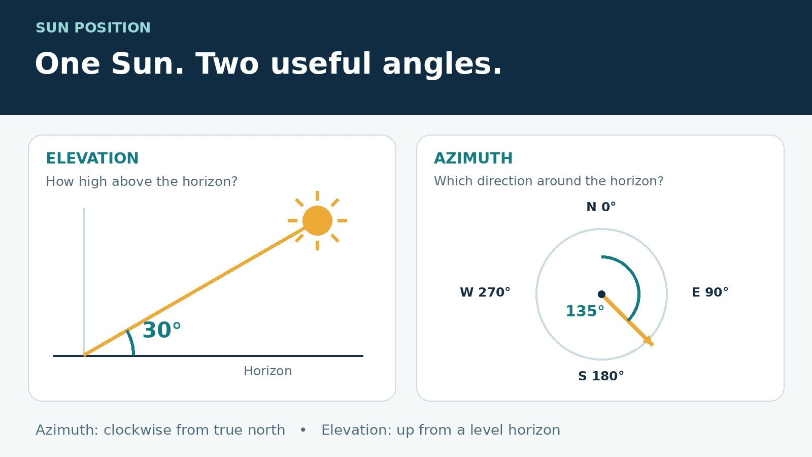
Azimuth is measured clockwise from true north: north 0°, east 90°, south 180°, west 270°. An azimuth of 135° points southeast. A magnetic compass may need a local magnetic-declination correction.
Elevation: up
Geometric elevation is the angle of the Sun’s center above a level horizon. At 30°, the Sun is one-third of the way from the horizon to overhead. Negative elevation places its center below that horizon.
Zenith: down from overhead
Zenith equals 90° − elevation. Elevation 30° gives zenith 60°; elevation −10° gives zenith 100°. The relation holds below the horizon too.

Geometric and apparent elevation differ. Refraction bends sunlight through the atmosphere, making the Sun appear higher near the horizon. The large result and its matching zenith use geometric elevation; the separate apparent value adds a standard approximate refraction correction. Neither predicts whether clouds or an obstruction hide the Sun.
At the exact poles, a unique north-referenced azimuth is not defined in the usual way. It is also unstable when the Sun is directly overhead or underfoot. The tool marks those cases as undefined instead of inventing a compass bearing.
Solar noon, sunrise and daylight
Solar noon is the Sun’s meridian transit. It is usually close to the day’s greatest elevation at low and middle latitudes, but it need not occur at 12:00. Longitude, the chosen time zone and the equation of time all contribute.
Sunrise and sunset use the conventional geometric center elevation of approximately −0.833°. This combines the Sun’s apparent radius with an average near-horizon refraction allowance. Consequently, a small negative geometric elevation can coexist with the Sun’s upper edge being visible.
Daily event times are computed for the selected local calendar date, independently of the time entered for the position. A polar-summer date can have 24 hours of daylight and no sunrise or sunset on that date; a polar-winter date can have zero. Transition dates may contain only one event. “Daylight in this date” counts the part of local 00:00–24:00 above the standard rise/set threshold, so it remains meaningful when a daylight interval crosses midnight.
The phase label uses the center’s geometric elevation: below the standard horizon threshold through −6° is civil twilight, down to −12° nautical twilight, and down to −18° astronomical twilight. These are geometric classifications, not measurements of brightness or safe visibility.
Worked examples you can check
1. Dubai: clock noon is before solar noon
Use 21 June 2026, 12:00, latitude 25.2048°, longitude 55.2708°, UTC+4. The calculated geometric elevation is approximately 84.96° and azimuth approximately 109.45°. Solar noon is about 12:21 local time. These are rounded model outputs, not a weather forecast.
With longitude λ positive east, equation of time E in minutes and offset z in hours, solar noon is approximately 720 − 4λ − E + 60z minutes after local midnight. Taking E ≈ −1.8 minutes gives 720 − 221.0832 + 1.8 + 240 ≈ 740.7 minutes, or about 12:21. The live calculation refines E for the event.
2. A 2 m post in a 45° Sun
For a vertical post of height H on level ground, shadow length is L = H ÷ tan(α), where α is the Sun’s elevation above the horizon. With H = 2 m and α = 45°, tan(45°) = 1, so L = 2 m. At 30°, L = 2 ÷ 0.57735 ≈ 3.46 m. Keep height and shadow in the same length unit.

If the Sun’s azimuth is 135°, the shadow’s bearing is (135° + 180°) mod 360° = 315°, northwest. This idealized geometry ignores sloping ground, the finite solar disk and refraction. Do not apply the simple shadow formula when the Sun is at or below the horizon.
Use the scientific calculator in degree mode to check the tangent, and the length converter if the measurements use different units.
3. Seasonal noon height
At meridian transit, an ideal geometric estimate is 90° − |latitude − declination|. At latitude 40° north, a declination of +23.44° gives 73.44°; a declination of −23.44° gives 26.56°. This 46.88° difference explains why winter shadows can be much longer at the same place.
The Earth’s rotation drives the daily apparent motion. Its axial tilt and orbit change declination through the year. Being closer to the equator does not always mean a higher Sun: at noon the relevant comparison is distance from the Sun’s declination. Within the tropics, the noon Sun can lie north or south depending on the season.
Method and accuracy limits
The tool converts local date/time to UTC, calculates Julian time and uses the NOAA-published Meeus-based solar equations for declination and equation of time. Spherical geometry then gives hour angle, zenith and azimuth. Daily rise/set estimates find when the geometric center crosses −0.833°. This page deliberately accepts 1901–2099; that is its supported input range, not a claim about the full range of astronomical methods.
For latitude φ, declination δ and hour angle H, cos(zenith) = sin(φ)sin(δ) + cos(φ)cos(δ)cos(H). True solar time combines local minutes with E + 4λ − 60z. Every trigonometric angle must use a consistent degree/radian convention. The astronomical unit converter covers distances; the angles here describe direction, not distance to the Sun.
- Displayed precision is not guaranteed accuracy. Two decimal places help compare inputs; they do not establish hundredth-degree observational precision.
- High-latitude events are especially sensitive. A shallow path near the horizon magnifies the effects of refraction, terrain and observer height.
- No terrain or weather model is included. A roof, hill or tree may delay direct sunlight even after calculated sunrise.
- This is not a solar-output or safety-critical navigation tool. Panel energy yield also needs irradiance, weather, orientation, electrical losses and shading. Photography and garden planning still require local observation.
NOAA’s linked calculator documentation now carries an unsupported/unmaintained notice. It is cited for published equations and definitions; no NOAA endorsement or service guarantee is implied. For consequential timing or engineering decisions, verify with an appropriate professional service.
Common mistakes and quick fixes
- Wrong time zone: match the offset to the entered local time and date, including daylight saving. The tool cannot infer it from longitude.
- Mixing degrees and clock minutes: Earth’s rotation corresponds to about 15° of hour angle per hour, or 1° per four minutes. Equation-of-time output is in minutes of time.
- Confusing azimuth with panel tilt: azimuth is a horizontal bearing. A panel’s tilt is a different angle.
- Expecting sunrise exactly east every day: its direction changes with season and latitude. “East” is an approximate equinox description for many locations, not a year-round rule.
- Reading “no sunrise” as “always dark”: inspect daylight duration and the daily status. The Sun may stay above the horizon throughout the date.
Practice: interpret the result
Try each question before opening its answer.
1. Elevation is 27°. What is the zenith angle?
63°. Subtract 27° from 90°.
2. The azimuth is 270°. Which direction is the Sun?
West. Azimuth is measured clockwise from true north.
3. A place uses UTC+5.75. What UTC time matches 18:15 there?
12:30 UTC. Subtract 5 hours 45 minutes. Decimal .75 of an hour is 45 minutes.
4. A 3 m post stands on level ground with elevation 30°. Find its shadow.
Approximately 5.20 m. L = 3 ÷ tan(30°) ≈ 3 ÷ 0.57735 = 5.196 m.
5. The Sun is at azimuth 250°. What is the shadow bearing?
70°. Add 180° to get 430°, then subtract 360°. The shadow points in the opposite horizontal direction.
6. Changing 09:00 to 15:00 changes elevation. Should that date’s sunrise also change?
No, if the place, date and fixed UTC offset are unchanged. The position belongs to an instant; the daily event belongs to the calendar date. This calculator computes those separately.
Frequently asked questions
Can this show where the Sun is right now?
Yes. Set the coordinates and correct current UTC offset, then use Current Date & Time. Verify the summary. The optional place label is descriptive and does not geocode an address.
Why is the Sun still visible at negative elevation?
The main elevation is for the geometric center. Near sunrise or sunset, refraction and the size of the solar disk can leave the upper edge visible while the center is slightly below the horizon.
Why is the result different from another app?
First compare the exact date, time, offset and coordinate signs. Then check whether elevation includes refraction, whether the horizon is level, and whether observer height or different solar algorithms are used.
Does a positive elevation guarantee direct sun on my window?
No. Compare the Sun’s bearing with the window orientation and its elevation with the height of surrounding obstructions. Clouds and shading remain outside this calculator.
Why can a polar date show only sunrise or only sunset?
Near the start or end of the midnight-Sun season, the daily daylight interval can cross the calendar boundary. The tool counts only the portion inside the entered local date and lists events that occur in that date.
Sources & References
Primary technical references checked 4 October 2026. Explanations, diagrams and practice questions on this page are original.
- NOAA: solar calculation details — Meeus-based method, refraction model and limitations; the service is no longer actively maintained.
- NOAA: solar calculator glossary — azimuth, elevation, zenith and solar-noon conventions.
- NOAA: general solar-position equations (PDF) — solar-time and spherical-geometry relationships; its low-order seasonal approximation is distinct from the Julian-time method used here.
- U.S. Naval Observatory: rise, set and twilight definitions — horizon conventions, the solar disk and observational uncertainty.